
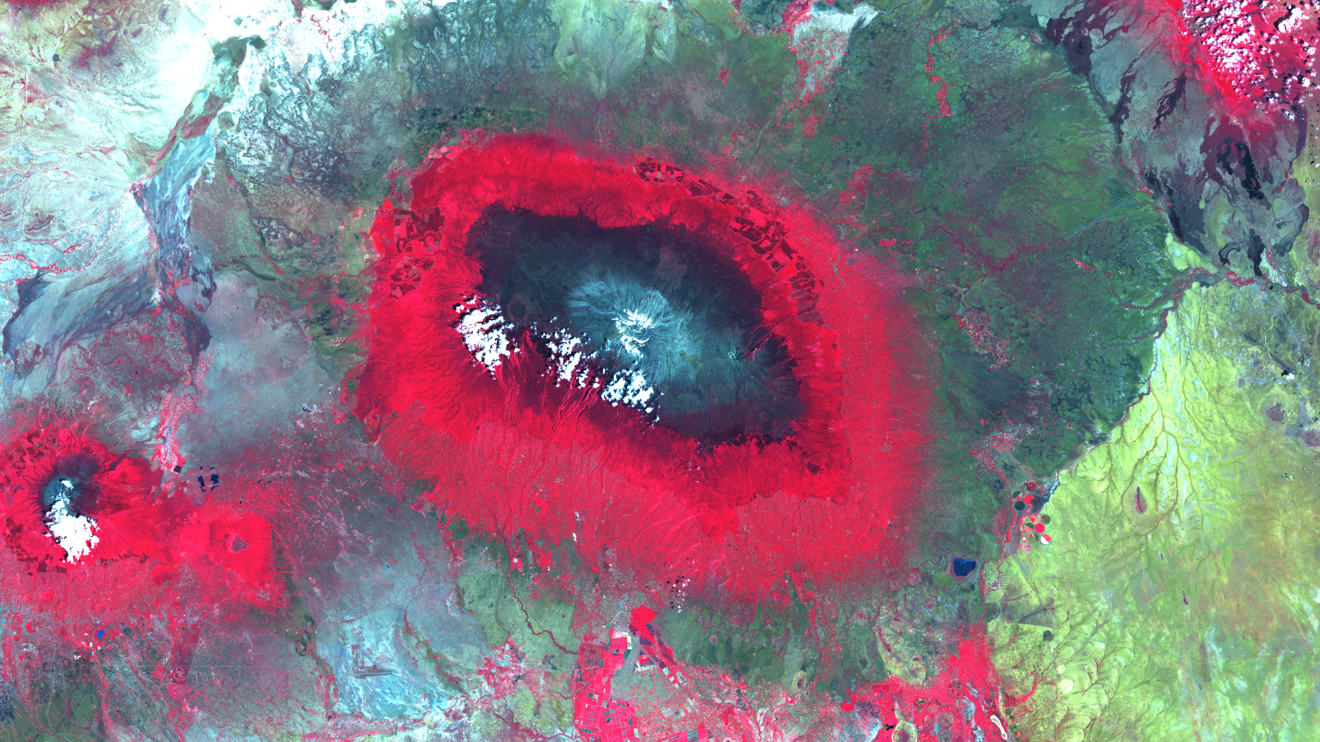
Kilimanjaro – Tanzania – recorded by the Sentinel-2A satellite on January 28, 2023
Our satellite image of the month May shows Mount Kilimanjaro in Tanzania and its surroundings.
The image is based on Sentinel-2 data from the EU Copernicus programme. Sentinel-2 data consists of freely available multispectral satellite images. After the download, the scene was atmospherically corrected using free software, and subsequently, a colour composite was calculated using three different bands. For this composite, bands 3 (green), 4 (red) and 8 (near infrared) were used, which provide a spatial resolution of 10 metres.
The chosen colour infrared (vegetation) composite is particularly well suited for visualising vegetation. Vegetation appears in various shades of red, older vegetation in green, soil in shades of brown and green, urban areas in blue-grey, clouds, snow and ice are light turquoise or white.
About the mountain massif
Mount Kilimanjaro is the highest mountain massif in Africa and one of the most famous mountains in the world. It is located in Tanzania, in the eastern part of the continent, close to the border with Kenya. Its summit lies about 5,895 metres above sea level. The mountain consists of three extinct volcanoes: Kibo, Mawenzi and Shira. Kibo is the highest peak and is home to the famous Uhuru Peak, which is the destination of most mountaineers who climb Kilimanjaro. Kilimanjaro is in the centre of the picture. To the south-west of it, Mount Meru can also be seen in the image.
Kilimanjaro’s flora and fauna are diverse and unique. From tropical rainforests to alpine desert landscapes, the massif offers a wide range of habitats for a variety of plant and animal species, including elephants, monkeys and numerous bird species. Kilimanjaro is not only a challenging mountaineering destination, but also an important symbol for Tanzania and the African continent as a whole. Its beauty and appeal attract thousands of visitors every year.
Vegetation zones on Kilimanjaro
The image clearly shows the different vegetation zones that form at different altitudes. In particular , the rainforest belt, which lies between 1,400 m and 3,000 metre above sea level, stands out with a bright red colouring in the image due to the false colour composition. The area below the rainforest is used for agriculture, and is shown in a slightly less intense red colour. The area surrounding the mountain is dominated by grass and tree savannah, which are depicted in shades of green and grey. Above the rainforest belt there are bush and grasslands, which are shown in a lighter shade of red. Above 4,000 metres, a rocky surface dominates, presented in blue-grey tones. Only on the summit of Kibo, there is a small ice cap of approx. 1.85 km², which has shrunk considerably in recent decades. It can be recognised on the satellite image as a white surface, not to be confused with the clouds to the south-west of the summit, which are also white.
A different view of the region
The following illustrations help to place the satellite image geographically. The orange boxes help to put the shown region into context. They show the location of the Kilimanjaro massif on the border with Kenya and the location of the area in East Africa.
The last picture impressively shows how the underlying map elements are reflected in the satellite image (e.g. through colour differences). The maps were produced using the OpenStreetMap Premium service provided by our sister company terrestris.
Contains modified Copernicus Sentinel data (2023)/ESA – created by mundialis