Flood analysis with the help of Sentinel-1 data

Development and VALidation of earth observation-based indicators for monitoring the Sendai Framework using the example of floods in Ecuador (VALE)

Challenge

As part of the project, mundialis has developed a method for extracting flooded areas from the Sentinel-1 data and aggregating them over an observation year. Due to their low surface roughness, water surfaces reflect the radar satellite signal away from the sensor, so that they appear very dark in the Sentinel-1 data. An automatic threshold value method combined with image segmentation can then identify flood areas and distinguish them from permanent water areas with the help of a reference data set. The figure shows a project result for one of the study areas examined in detail as part of the project.
If all Sentinel-1 images of a year are analyzed in this way, temporally aggregated flood hazard maps can be derived. Combined with other auxiliary data sets on local population, land use, etc., these results can then be converted into indicators of the Sendai Framework.
The method developed can be used for any investigation area and time period. The long-term Copernicus program guarantees the continuous collection of Sentinel-1 data.

Services

The company mundialis has fully implemented the project. The implementation took place in the following work steps:

  • Data research, import and analysis of input data
  • Development of the internal process scripts for the question
  • Interaction with the project partners to optimize the calculations
  • On-site inspections of project areas in Ecuador, workshops
  • Extraction of the flooded areas from the Sentinel-1 data
    • Temporal aggregation of this data over an observation year
    • Development of an automatic threshold value method combined with image segmentation to identify flooded areas
    • Differentiation of permanent flooded areas with the help of a reference data set
    • Derivation of temporally aggregated flood hazard maps
  • Conversion of the results into indicators of the Sendai Framework
  • Automation of the developed method
  • Quality assurance of the results data
  • Transfer of data and documentation to the project partners
  • Final meeting
Result
  • Implementation of the method
  • Conversion of the results into indicators of the Sendai Framework
  • Provision of the software on GitHub as open source
  • Scientific publication (peer reviewed)
Customer
BMWI (Federal Ministry for Economic Affairs and Energy)

Story

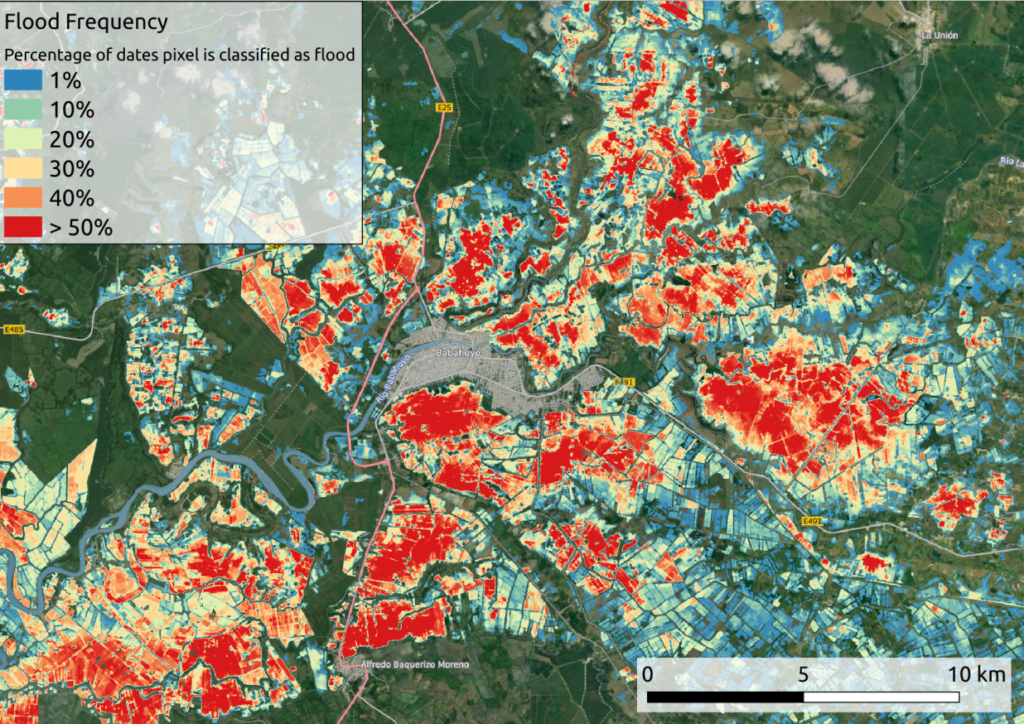
Flooding is one of the most frequent natural disasters worldwide, and the damage caused can often only be quantified very imprecisely, depending on the region affected. The Sendai Framework for Disaster Risk Reduction 2015-2030 is therefore based on a series of standardized indicators that are intended to reflect the annual impact of natural disasters as fully as possible. The BMWI-funded research project VALE(Development and validation of earth observation-based indicators for monitoring the Sendai Framework using the example of floods in Ecuador) is investigating the extent to which remote sensing data can be used to calculate these indicators. Specifically, it is about the derivation of annual flood statistics using the example of Ecuador.

Flood Frequency Map