Surface classification

Objective: precise estimates of the change in carbon storage and annual carbon uptake capacity per hectare due to the conversion of open spaces into settlement and transportation areas

Challenge

Gertz Gutsche Rümenapp (GGR) is working together with the Öko-Institut on a research project for the Federal Environment Agency to assess the greenhouse gas impact of land conversion.
“Land conversion” refers to the conversion of open space areas (“before” state) into settlement and traffic areas (“after” state).
For both states, the carbon (C) storage and the annual C uptake capacity per hectare are estimated and the difference determined.
For this purpose, an automated surface classification (buildings, roads, gardens, forest, meadow, …) will be used.
Against this background, the following empirical task arises.
A larger sample of existing settlement areas (selected ATKIS sub-areas) is to be evaluated using suitable data sources (including aerial photographs).
For each ATKIS area evaluated, the following result should be obtained at the end:

  • Area shares of the surface classifications “Area (sqm)”
  • Number of trees
Services

mundialis has fully implemented the surface classification.
After reading and analyzing the customer’s input data and adapting the internal process scripts to the customer-specific solution requirements, the surface classification was created in the following classes:

  • Sealed floor
  • Low vegetation – unbound soil, grass, etc.
  • tall vegetation – trees (see 2nd classification)
  • Buildings from official stock
  • Water areas, divided into
    • Pools
    • Ponds
    • Public water areas (lakes, streams, rivers)
  • Buildings from non-official stock (garden sheds, carports, etc.)
  • Trees in the min.
    four categories:

    • Bushes/woods: 0.5m to 2m high
    • small trees: 2-3 m height
    • Medium trees: 3-6 m height
    • Large trees: > 6m height
  • and the other tree attributes
    • Height
    • Tree crown diameter
    • Area under trees
    • 95th percentile
    • Tree canopy circumference
    • Type of area under trees
    • Home position
  • Summary attributes per ATKIS area and per study area
    • Number of small trees
    • Number of medium-sized trees
    • Number of large trees
    • m2 of the sealed area
    • m2 of unbound soil
    • m2 of trees
    • m2 of buildings in total
    • m2 of small buildings/structures
    • m2 of the sealed area of the public roads
    • m2 of “private sealing”

This was followed by quality assurance of the results data and handover of the data and documentation to the client, including a final meeting.

Result
  • Development of customer-specific process scripts
  • Calculation of the surface classification with six classes
  • Identification of trees in four categories
  • Quality assurance of the results data
  • Handover of the data and documentation to the client
Customer
Gertz Gutsche Rümenapp Urban Development and Mobility GbR

Story

Land conversion, i.e. the conversion of natural open spaces into settlement and traffic areas, is a key issue in the context of climate change and sustainable urban development. When forests, meadows or other natural landscapes have to make way for residential and industrial areas, this has far-reaching effects on the environment, especially on carbon storage and the emission of greenhouse gases.
Against this background, Gertz Gutsche Rümenapp (GGR ), in cooperation with the Öko-Institut, is investigating the greenhouse gas effects of such land conversions on behalf of the Federal Environment Agency. The aim of the project is to provide precise estimates of how carbon storage and the annual carbon absorption capacity per hectare change as a result of the conversion of open spaces into settlement and traffic areas.
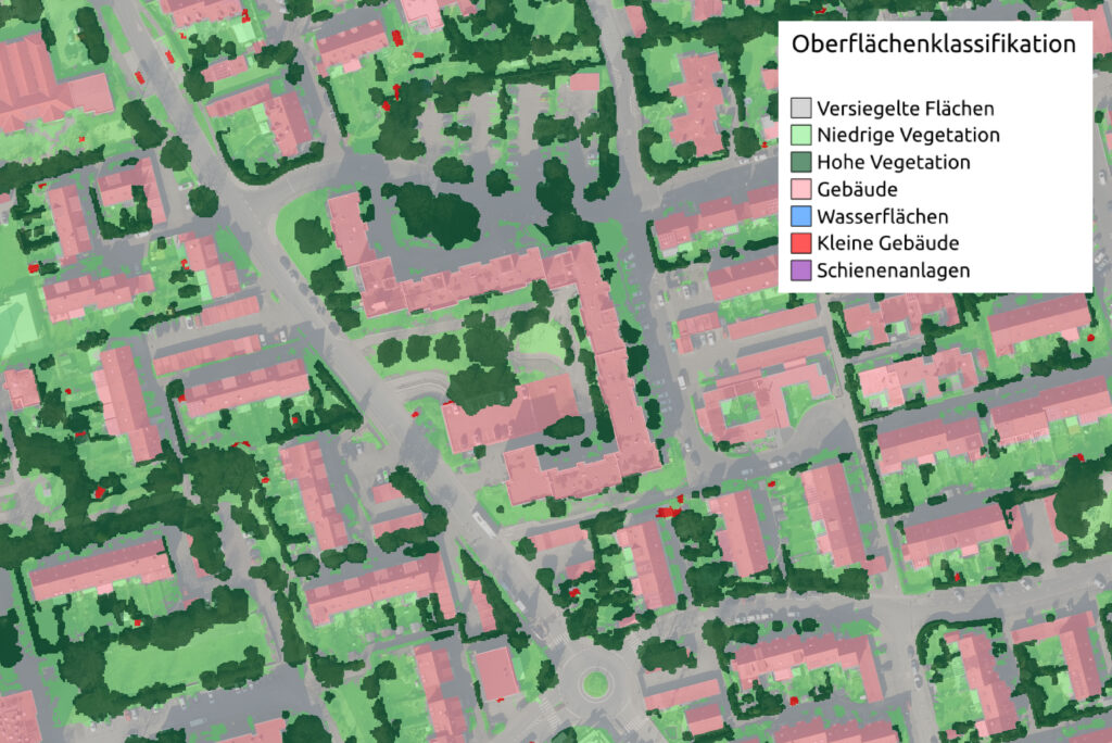
To this end, modern methods of automated surface classification are used, which make it possible to identify and analyze different types of areas such as buildings, roads, gardens, forests and meadows. A comprehensive evaluation of a large sample of existing settlement areas, based on data sources such as aerial photographs, forms the empirical basis of this study.