
Open Data Day is coming soon!
Every year, Open Data Day (ODD) serves as a global celebration of open data, highlighting its importance in fostering transparency, innovation, and collaboration across various industries. Maintained and supported by the Open Knowledge Foundation (OKFN) through the Open Knowledge Network, ODD encourages groups worldwide to create local events where they use open data in their […]
Satellite Image of the Month – February – Mangoky Delta (Madagascar)
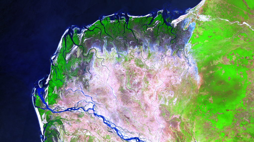
Mangoky Delta – Madagascar, captured by the Sentinel-2B satellite on January 10, 2025 Our satellite image of the month for February features the delta of the Mangoky River on the west coast of Madagascar. Image Composition The image is based on Sentinel-2 data from the EU Copernicus Program. Sentinel-2 data consists of freely available multispectral […]
🌱 Updates on CO₂e Compensation at mundialis for 2023
In line with our environmental management system and the ISO 14001 certification that we received at the end of 2023, we are committed to reducing the environmental impact of our travel activities. The amount of CO₂e generated by our corporate mobility is offset at the beginning of each year for the previous year. The resulting […]
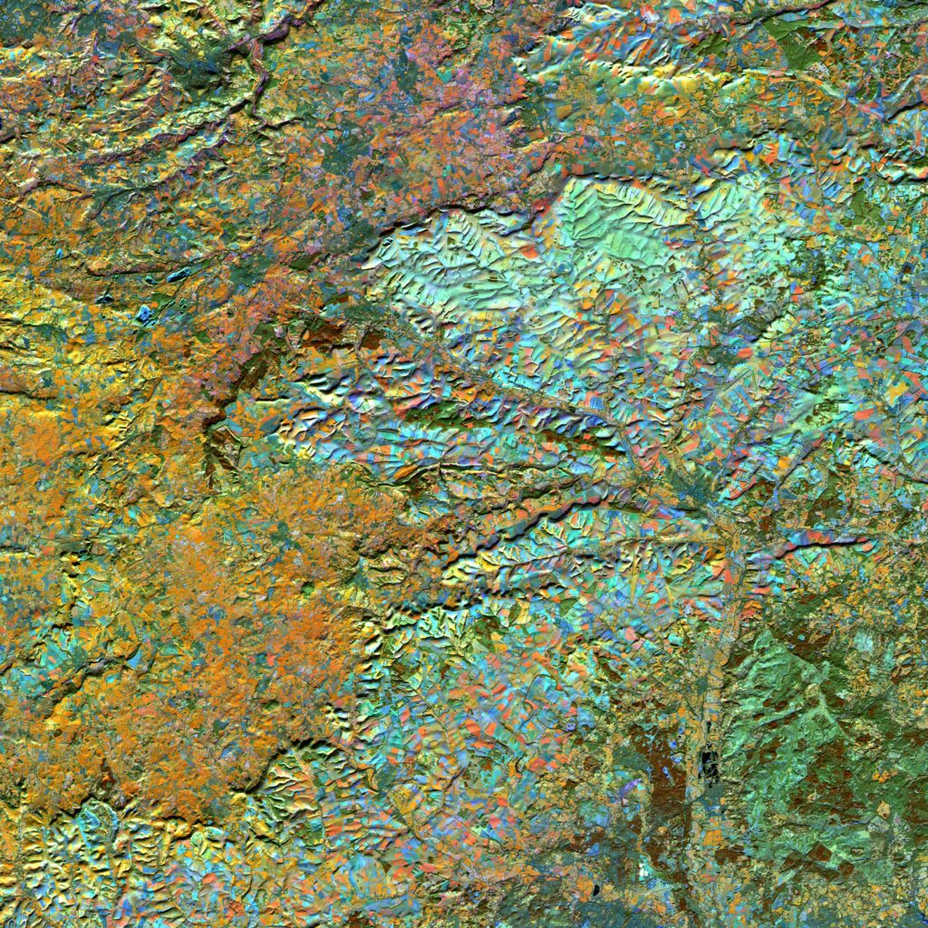
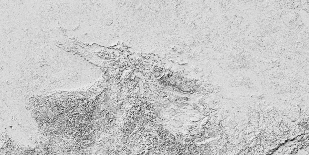
Satellite Image of the Month – January – Malaspina Glacier (Alaska, USA)
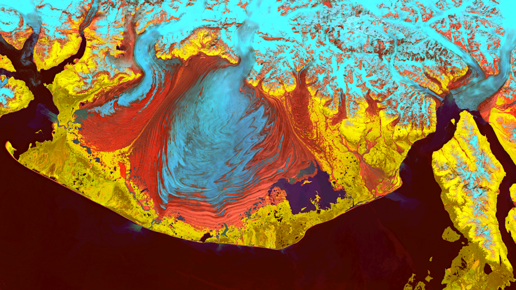
Satellite Image of the Month January 2025: Malaspina Glacier (Alaska, USA) Our Satellite Image of the Month for January features the Malaspina Glacier on Alaska’s Pacific Coast. Structure of the image The image is based on Sentinel-2 data from the EU Copernicus program. Sentinel-2 data are freely available, multispectral satellite images. After downloading, multiple scenes […]
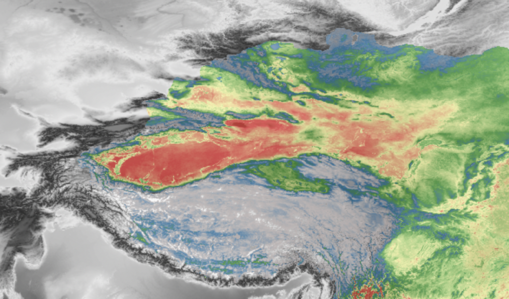
Satellite image of the month – December – Mahalangur Himal (Nepal/China)
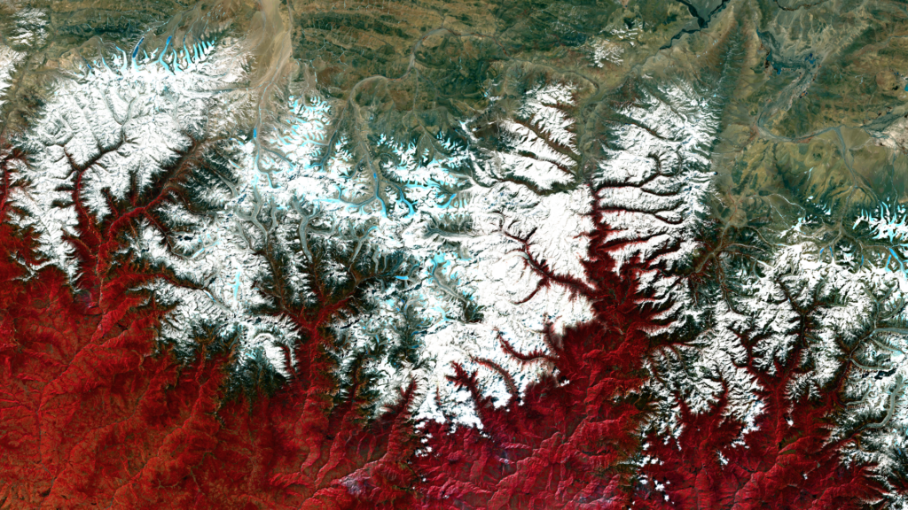
Mahalangur Himal– Nepal/China – recorded by the Sentinel-2B satellite on March 17, 2024 Our satellite image of the month December shows the Mahalangur Himal massif, which is part of the Himalayas and home to the world’s highest mountains, including Mount Everest, also known in the region as Sagarmatha or Qomolangma. Structure of the image The […]
Better Assessment of Heavy Rainfall Risks: First Training on the GRASS GIS Tool r.sim.water
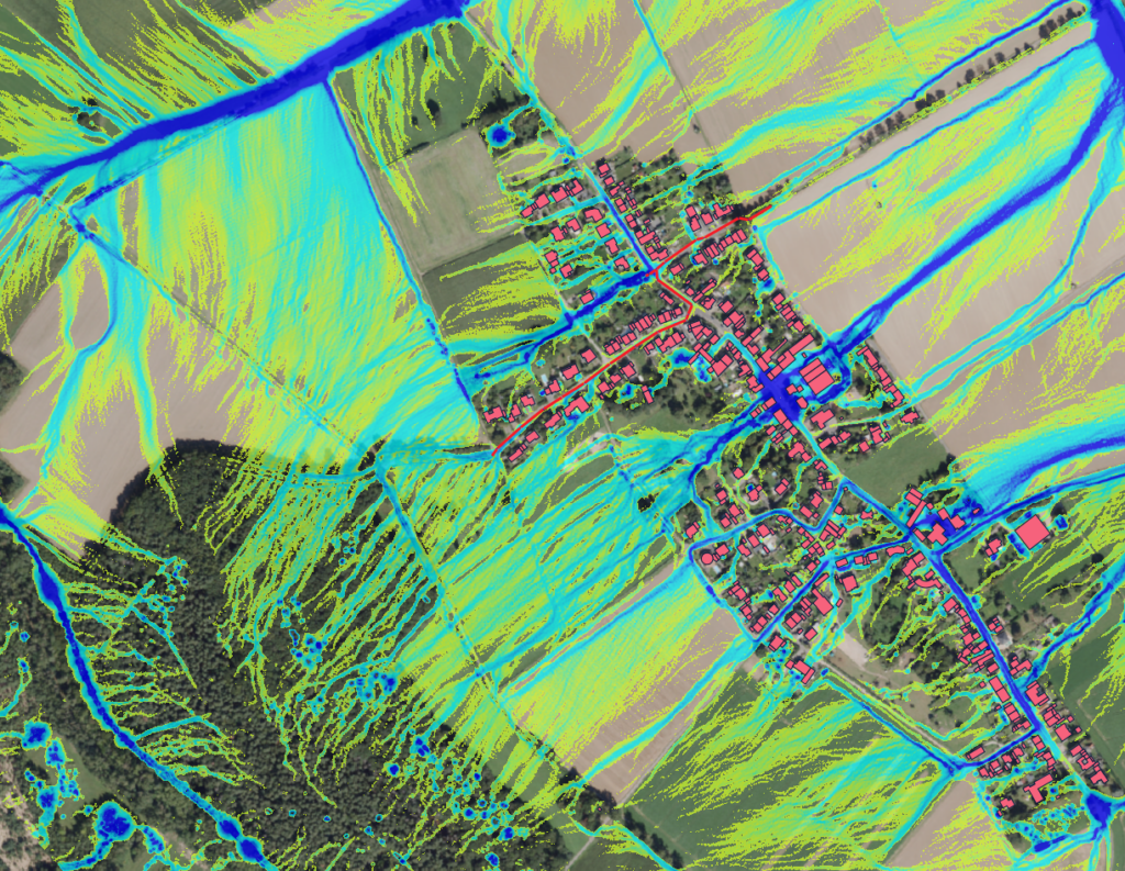
We are pleased to report on the first training session for the GRASS GIS tool r.sim.water that we conducted for the city’s drainage department in Düren. The goal was to improve the assessment, visualization, and simulation of flooding potential during heavy rainfall events. r.sim.water is a powerful tool for simulating water runoff, providing detailed insights into how water […]
VALE Project included in the ESA’s SDG Catalog
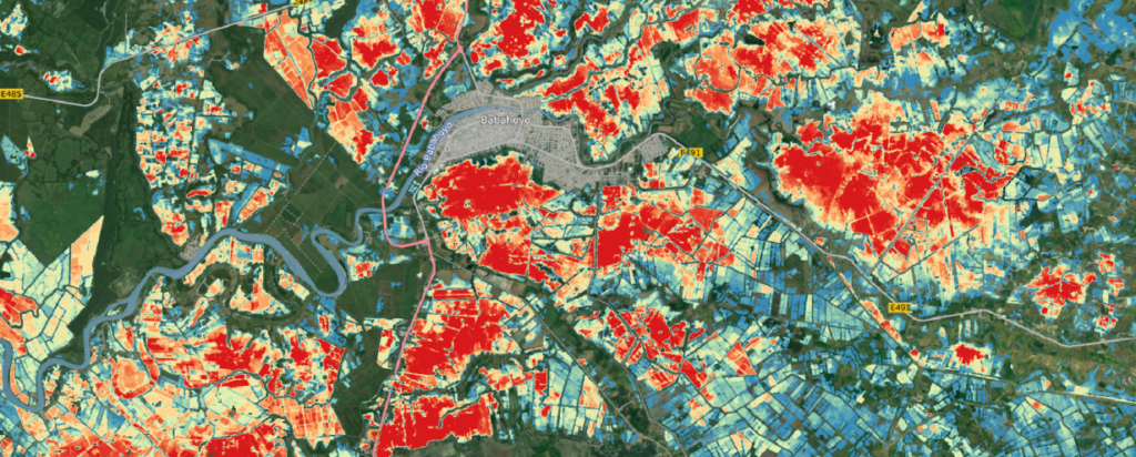
Unser Projekt VALE (Entwicklung und VALidierung von erdbeobachtungsbasierten Indikatoren für das Monitoring des Sendai Rahmenwerks am Beispiel von Hochwasser in Ecuador), das sich auf die Hochwasseranalyse mit Sentinel-1-Satellitendaten konzentriert, wurde offiziell in den SDG-Katalog der ESA aufgenommen! 🎉 Dies ist eine bedeutende Anerkennung für unsere Arbeit zur Erreichung der UN-Nachhaltigkeitsziele (SDGs). Im Projekt VALE haben wir eine Methode […]
Exciting news from the world of geoinformatics and environmental analysis
We are pleased to announce a pioneering partnership between mundialis GmbH & Co KG from Bonn and Margosa Environmental Solutions Ltd. from the UK. This collaboration combines the strengths of two innovative companies to develop holistic solutions for complex environmental and resource issues. Margosa Environmental Solutions Ltd. brings its extensive expertise in hydrology and geomorphology […]
GRASS GIS Add-ons from mundialis
We are pleased to present an extensive list of GRASS GIS addons developed by mundialis. 🔗 Click here for the overview The variety of tools offered with detailed descriptions and their simple integration options make the add-ons particularly useful for your GIS projects. To name a few examples:
KIBI: AI-based identification and classification of protected plant communities

We are pleased to announce our upcoming research project KIBI!Together with our partners Koblenz University of Applied Sciences and Forschungszentrum Jülich under the consortium leadership of CISS TDI GmbH, we will tackle the precise mapping of protected plant communities (GPG) using satellite and aerial survey data. We use machine learning to identify and classify GPGs […]